My research interests focus on assessing groundwater flow in porous media, evaluating the role of anthropogenic and climatic effects on groundwater reservoirs, citizen science, geoscience education, and studying variations in water quality/quantity in surface- and ground water systems.
Saltwater Intrusion
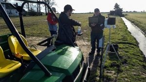
Saltwater intrusion is impacting agricultural fields in eastern North Carolina. My research team is collaborating with scientists and agriculture extension officers from North Carolina State University, and farmers in Hyde, Camden, and Pasquotank counties to investigate the drivers and sources of saltwater intrusion in low lying regions of eastern North Carolina. The research team will use a suite of groundwater/surface water monitoring stations (water level, temperature and salinity), hydrologeological techniques, geophysical techniques (ground penetrating radar, capacitively-coupled resistivity, direct current electrical resistivity), soil sampling/monitoring (soil conductivity, soil temperature, soil moisture content), and weather data to characterize water quality and quantity, and the structure and composition of the subsurface.

A news article in the Washington Post on this project can be found here.
This project was partially supported by the National Science Foundation.
Coastal Hydrogeology
I am interested in studying groundwater systems in coastal regions. These systems are at risk by natural and anthropogenic threats that include sea level rise, environmental degradation, population growth and saltwater intrusion.
Investigating 2D porosity structure in the Castle Hayne limestone of North Carolina using geospatial analysis
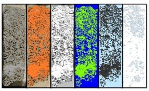
Limestone aquifers are vital sources of groundwater for domestic and industrial use throughout the world. To sustain rising population throughout the southeastern United States, aquifers are increasingly exploited to provide the populace clean and reliable water resources. The moldic Castle Hayne is a highly productive aquifer that provides critical water resources to citizens in eastern North Carolina. In order to better understand karst aquifers and evaluate the potential for contaminant transport, we are undertaking an investigation of 2D porosity and pore geometry using image and geospatial analysis. The objective of this study is to assess the porosity structure of moldic porosity by quantifying 2D porosity and pore geometry from images of thin sections, slabbed core samples and optical televiewer images. This study presents an example of how quantitative measures of pore attributes and structure can be used to assess karst media with unique porosity characteristics. Such measures will lead to a better understanding of porosity structure in karst aquifers that can be useful for designing and running ground water flow models and assessing transport mechanisms in karst media.
Assessing groundwater quality and quantity in the southern Albemarle Estuarine System, eastern North Carolina
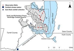
Spatial and temporal distributions of salinity in the groundwater system of the southern Albemarle Estuarine System (AES) are being monitored to assess the impact of an artificial canal system on surface and groundwater quality and quantity in the Emily and Richardson Preyer Buckridge Coastal Reserve. Specific conductivity measurements are used to quantify salinity changes in surface and groundwater within the interior of Buckridge reserve and along the shoreline of the reserve adjacent to the Alligator-Pungo canal and the Alligator River sections of the Intracoastal Waterway (ICW). Unlike other estuarine systems on the east coast, the AES is unique because it is dominated by freshwater. The lack of a direct outlet from the Albemarle Sound to the Atlantic Ocean prevents high concentrations of saltwater from mixing with freshwater in the AES. As a result, the salinity in the Albemarle Sound can range from 1- 4 ppt (average salinity of sea water is 35 ppt) in the main stem of the Albemarle Sound for most of the year. However, elevated levels of salinity have been observed in Buckridge Reserve. These elevated levels have been attributed to storm overwash that is derived from wind tides and storm surges. The goal of this study is to resolve fundamental mechanisms related to the impacts of wind driven tides/storm surges on the source, transport and residence times of saltwater in a coastal wetland and adjacent areas. This project is funded by the North Carolina Department of Environment and Natural Resources.
Groundwater flow and water table position within the surficial aquifer, Emerald Isle, North Carolina
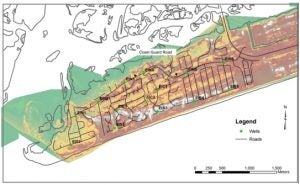
The surficial aquifer is the upper layer of sediments overlying all of the North Carolina Coastal Plain. The sediments, ranging in thickness from ~6 m to ~60 m, consist mostly of sand with some minor deposits of silt, clay and peat beds. The surficial aquifer is a water table aquifer, meaning that it is an unconfined aquifer that is in direct communication with the atmosphere. Even though the surficial aquifer is one of the thinnest of all the aquifers, it is an extremely important aquifer because it receives direct recharge from precipitation and in some places is also the major source of water for underlying aquifers and base flow to streams in the Coastal Plain. On the western end of Emerald Isle, North Carolina, storm water flooding arising from a saturated surficial aquifer has been a problem for a long period of time. The main goal of this project is to evaluate the hydrology of the surficial aquifer on Emerald Isle. Specifically, we will utilize site specific and complete data sets to determine the position of the water table, the groundwater flow regime and the hydrologic properties of the surficial aquifer. we will also derive a water budget for western part of Emerald Isle, assess the impact of a high water table on storm water runoff and evaluate alternatives for lowering groundwater levels and/or reducing the impact of excess storm-water runoff. This project is funded by the Town of Emerald Isle.
Assessing the impacts of climate on long term groundwater levels in eastern North Carolina
Groundwater is an important source of potable water for communities in many parts of North Carolina. Unfortunately, few studies have comprehensively evaluated how groundwater levels vary in the state. This study seeks to assess the temporal and spatial variations of the shallow groundwater system and its response to precipitation in North Carolina. The goal of the study is to document changes in the subsurface component of the hydrologic cycle over regional and decadal scales over the last thirty years. Time series analyses are use to investigate the response of the groundwater system to precipitation. Groundwater level precipitation data are obtained from the North Carolina Department of Environment and Natural Resources’ (NCDENR), Division of Water Resources and the United States Geological Survey (USGS). Normalized anomalies are used to assess groundwater trends with respect to precipitation in an attempt to determine any important trends and evaluate any associations between groundwater levels and precipitation. The importance of this study is that the results could be useful in assessing the impact of climate change and variability on groundwater resources.


